Dozens of landslides scar the hillsides of Fforest Fawr Geopark – this page lets slip why they happened and where they are.
Signs of past landslides can be found throughout the Old Red Sandstone hills of the Geopark. Apart from one, all the major slips have occurred within the Brownstones and Senni formations – the sequences of sandstones and mudstones that form much of the upper part of the Old Red Sandstone. To the south the rocks of the Coal Measures are prone to slipping too. Though we don’t know how old most slips are, they are thought to largely date from after the last ice age when hillsides that had been over-steepened or undercut by ice or meltwater, slumped down into the valleys.
The British Geological Survey maintains a National Landslide Database on its website. BGS encourages anyone who spots a landslide to report it via that page so if you spot a fresh one in or around the Geopark let them know – and drop us a line too!
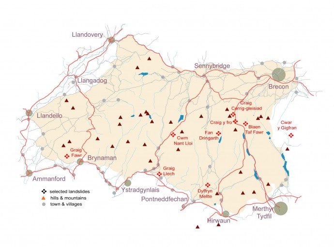
Some notable older examples from around the Geopark are described below. All of the locations can be found on Ordnance Survey Explorer map sheet OL12 ‘Brecon Beacons National Park; Western Area’. The British Geological Survey’s 1:50,000 scale maps 213 ‘Brecon’, 230 ‘Ammanford’ and 231 ‘Merthyr Tydfil’ provide geological coverage. Many of these spectacular sites lie on or near the Beacons Way – some are encountered on other published walks.
- Note that the Ordnance Survey grid references and elevations above sea level for this selection of sites are only approximate.
Blaen Taf Fawr
A triangular section of the east-facing slope above the upper reaches of the Taff has slipped, perhaps after under-cutting by the stream. Best viewed from the Beacons Way en route between Pont ar Daf and Pen y Fan. Parking at Pont ar Daf at SN 987199
- Rock: sandstones of the Brownstones Formation
- Elevation: 550m / 1800ft
- Grid ref: SN 993206
Craig Cerrig-gleisiad
A major landslip – or series of landslips – whose origins are intimately connected with the glaciation of this cwm. Can be viewed in part from the A470 but a short walk into the cwm from the layby at SN 971222 gives the best views. Alternatively view it from above from the Beacons Way. The whole site has been designated as a national nature reserve.
- Rock: Senni Formation sandstones
- Elevation: 500m / 1600ft
- Grid ref SN 960220 – 975240
Craig y fro
Since the A470 runs right through it and there is a large parking area on its northern edge, this is the most accessible of all the landslips of the Geopark – if it’s a landslip, that is! Scientific debate continues as to whether the striking landforms seen at this spot owe their origins to ice or a slip. Get a bird’s-eye view from the Beacons Way which runs above it.
- Rock: Senni Formation sandstones
- Elevation: 380m / 1250ft
- Grid ref SN 973207
Cwar y Gigfran
Although this spectacular slip lies just outside the Geopark it is included here for being of considerable interest. Best viewed from the Beacons Way along Craig y Fan Ddu. Formed within the Brownstones Formation it extends from the high sandstone edge of Cwar y Gigfran down to the stream of Blaen y Glyn.
- Rock: Brownstones Formation sandstones
- Elevation: 600 -700m / 2000 -2300ft
- Grid ref: SO 060198
Cwm Nant Lloi
A slip just south of the pass of Bwlch Bryn-rhudd. The former Neath and Brecon Railway line passes through the middle of the slip as did the Brecon Forest Tramroad before it. It can be viewed from the A4067 Swansea road or the permissive path which follows the old railway from the pass. Park in layby at SN 867193
- Rock: Brownstones Formation sandstones
- Elevation: 400m / 1100ft
- Grid ref: SN 868188
Dyffryn Mellte
The steep eastern side of the gorge through which the Afon Mellte flows above its confluence with the Hepste has collapsed leaving a jumble of boulders over which the woodland has spread. The jointed sandstones and weak mudstones of the ‘Marros Group’ collapsed at some unknown but distant time as they were undercut by the river. Best viewed from the path down to Sgwd y Pannwr which runs through its midst – get the guide to the Four Falls Trail from the Waterfalls Centre.
- Rock: Marros Group sandstones and mudstones
- Elevation: 200m / 650ft
- Grid ref: SN 923104
Fan Dringarth
One of the most spectacular landslips in the whole Geopark and one of the least accessible and hence least known. The eastern side of the summit of Fan Dringarth has broken away and some of it now forms a great bulge of rocky debris looming above the Afon Dringarth at the head of Ystradfellte Reservoir. Visible from the Beacons Way as it runs along the mountain’s ridge.
- Rock: Brownstones Formation sandstones
- Elevation: 500m / 1600ft
- Grid ref: SN 942195 to SN 199188
Graig Fawr
Alone amongst the landslips of the National Park and Geopark, this one occurs within the mudstones and sandstones of the upper Coal Measures although landslips in these rocks are very common in the coalfield to the south. A couple of public footpaths run through the slip on the western wide of Cwm Pedol, west of Brynaman though it can be seen to advantage from the eastern side of the cwm. The ‘From Cwm to Cwm’ walk passes through it – free leaflet available locally.
- Rock: Coal Measures sandstones and mudstones
- Elevation: 250m / 850ft
- Grid ref: SN 695153
Graig Llech
A landslip (i) affected the path down the gorge of the Nant Llech a few years ago but is now stable. More recently (early 2016), another slip (ii) took out the path at the bottom of the gorge – the path has re-opened but the scar remains. There is evidence of earlier slips in places. Steep slopes cut into relatively weak rocks like these Coal Measures mudstones are often unstable and prone to slippage. Walk down from the National Trust car park at Henrhyd Falls.
- Rock: Coal Measures sandstones and mudstones, glacial till
- Elevation: (i) 230m / 750ft & (ii) 165m / 550ft
- Grid ref: (i) SN 843122 & (ii) SN 837123


