What is a Geopark?
A Geopark is an area that celebrates its interesting geology but then makes the links with its wildlife, its history, archaeology and much more and uses that to boost the wellbeing of its residents and the area’s visitor economy. There are now over 200 around the world – all different but all proud of their natural and cultural heritage and making it work for them at the same time as protecting it.
Where is our Geopark?
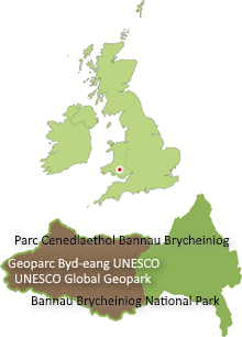
Fforest Fawr Geopark was designated in 2005 across 763km2 of the western half of the Brecon Beacons National Park. Its boundaries were – and remain presently – the same as those of the National Park in the north, west and south but its eastern boundary follows the Brecon Mountain Railway north from Pontsticill to Torpantau then the ‘Gap Road’ north to Llanfrynach.
Who manages the Geopark?
It is managed by a partnership of organisations from the public, private and charitable sectors, each bringing their own expertise to the table. Bannau Brycheiniog (Brecon Beacons) National Park Authority is the lead partner. Others include Cardiff University, Natural Resources Wales, Brecon Beacons Tourism, Brecon Beacons Park Society, British Geological Survey and Heneb, the newly combined Welsh archaeological trusts. See here for a more complete list.
What is UNESCO’s involvement?
UNESCO (the United Nations Educational, Scientific and Cultural Organisation) has run the networks of World Heritage Sites and Biosphere Reserves since 1971 and 1975 respectively. We’ve four of the former and one of the latter in Wales. In 2015 UNESCO took the network of Geoparks under its wing as its third key global project, so Fforest Fawr has been a UNESCO Global Geopark since that date. Every four years, UNESCO evaluators assess the performance of each Geopark and make recommendations based on what they find.
What has UNESCO said to us?
Our 2020 revalidation took place a year late due to Covid. We were given a ‘green card’ – a clean bill of health’ – to run until 2024. Amongst the recommendations we received in 2022 was one to consider expanding the Geopark to ‘make the most of the impressive mining heritage’ on our southern fringes. We are embarking on consultations with interested parties to see how we might do that. We are currently awaiting the result of our 2024 revalidation.
How far might the Geopark expand?
The Geopark can expand by up to 10% of its original area without having to re-apply to UNESCO for membership – that means we can include an additional 76km2. We’re looking at our southern fringe and in particular at areas with especially interesting natural and industrial heritage with interesting stories to tell. The expansion may include additional parts of the counties of Powys and Carmarthenshire and parts of the county boroughs of Neath Port Talbot, Rhondda Cynon Taf and Merthyr Tydfil. Apart from Neath Port Talbot, the Geopark already extends across some parts of all of these ‘principal areas’.
Who gets to say what’s included?
It is important that local communities have their say; that’s why we’re starting to talk to councils and community organisations south of the current boundary. Geopark status has to work for local people. We will be holding consultation events in communities in the area, starting in Neath Port Talbot. We expect to adjust our expansion proposals based on responses received from organisations and individuals and, at the end of this period, submit an application to modify the boundary to UNESCO who, if satisfied, have the power to confirm it.
Will the boundary of the National Park be affected?
No, these proposals will not affect the boundary of the National Park at all.
How might it affect me?
Though supported by Welsh Government and others, Geoparks are not a statutory designation like national parks. Designation of an area as a Geopark brings no additional planning controls for example; it does not change any rules for farmers and landowners regarding how they manage their land; it does not provide any additional access rights for members of the public. Geoparks have however been successful at bringing extra money into an area, both through spending by visitors and by attracting grant funding for projects aligned with Geopark objectives.
What benefits can a Geopark offer?
Geoparks can help raise the profile of an area to the benefit of visitor-focussed businesses and contribute to educational opportunities within communities. They have been shown to enhance community pride in their natural and cultural heritage with spin-offs for health and well-being.
Who will fund this?
The Geopark is co-ordinated by the National Park Authority which since 2005 has provided a small budget and employs a Geopark Development Officer. As mentioned above, funding for individual projects within the Geopark has typically been available through grants from a variety of bodies. It is anticipated that this will continue though individual unitary authorities are encouraged to make appropriate investments in their sector of the Geopark, in line with their own priorities for recreation, health, the local economy and so forth.
How will any new areas of the Geopark outside of the National Park be managed?
It is anticipated that the relevant local authority will take the lead, assisted as appropriate by the National Park Authority and other partners.
Where can I find out more?
You can check out the Geopark website at www.fforestfawrgeopark.org.uk or give the Geopark Development Officer, Alan Bowring a call on 01874 620415 or e-mail him at fforestfawrgeopark (at) beacons-npa.gov.uk
If you are in the Neath Port Talbot area, watch out for details of workshop events we’ll be organising in late 2024 in towns and villages in the area fringing the National Park.


