


After a series of thorough surveys over many years, hundreds of Regionally Important Geodiversity Sites (RIGS), have been designated across Wales (England’s equivalent are ‘Local Geological Sites’) . Behind geological Sites of Special Scientific Interest (SSSIs) they represent a second tier network of geological/geomorphological localities identified as important for their scientific, educational, aesthetic and/or historic nature. Though not given statutory protection like SSSIs, Welsh Government guidance to local authorities requires them to take account of RIGS in reaching planning decisions (Technical Advice Note 5, ‘Nature Conservation and planning’).
A RIGS can be designated in any of the four categories noted above, according to its interest though some will meet the criteria for designation in two, three or even all four categories. Various branches of the earth sciences are represented amongst the sites of this area, including the following; geomorphology, industry, karst, landslip, palaeo-environments, palaeontology, Quaternary studies, sedimentology, stratigraphy and structure.
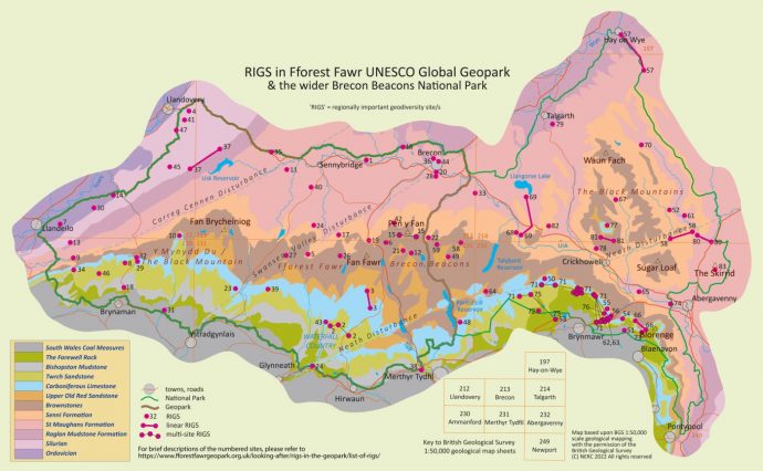
As of 2022, some 47 RIGS have been designated within Fforest Fawr Geopark, largely as a result of the audit of South Wales’ geology commissioned by Welsh Government in 2008 and carried out by the British Geological Survey (BGS). The BGS report of 2013 completed the coverage of the country though further RIGS may yet be designated on the basis of further work. Those within the Geopark vary considerably in size and character from a couple of thousand square metres centred on a road cutting north of Myddfai to around 11 square kilometres of upland common above the upper Swansea Valley.
Brecon Beacons National Park Authority is the planning authority for Fforest Fawr UNESCO Global Geopark as it is for the remainder of the National Park to the east of the Geopark. For this reason the further 36 RIGS identified in the east of the National Park, but outside of the Geopark, are listed for completeness.
Refer to the map to determine which of the BGS 1:50,000 scale geological maps covers any particular RIGS. All those within this Geopark RIGS list (RIGS 1-47) are to be found (though not identified) on OS 1:25,000 scale Explorer map sheet OL12 unless otherwise noted*
Please note that inclusion of a site in this list does not give any right of access; whilst many sites are wholly or largely within public access land and others can be viewed from roads or public paths, some are entirely within private land. To access any on private land please seek permission locally or, in case of difficulty, contact the SEWRIGS Group for assistance.